
 |
 |
News Features
Astor On The Edge As Flood Conditions Persist
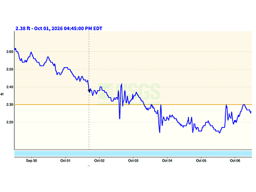
The St. Johns River in Astor surged into flood stage in recent weeks, with high water bringing boating speed restrictions to the area. The river, impacted by rains south of the area flowing north and steady winds from the north blowing south, rose to as much as 2.70 feet in late September before receding in recent days.
Early this week, the river remained in flood stage, but had fallen from a ‘minor flood stage’ category to ‘action’ stage, at roughly 2.15 feet, with the river expected to rise again heading into the weekend.
Fall flooding has become common in the Astor area in recent years, with high waters placing shorelines and property at risk and no wake boating restrictions reducing recreational traffic both on the water and in town.
Unfortunately, the relief may be short lived.
National Oceanic And Atmospheric Administration (NOAA) prediction models indicate it is believed the river will begin to rise again mid week, peaking again 2.70 feet and remaining there into the weekend. At three feet, the flood would be considered ‘moderate’. At that level, homes near Wildhog Road and nearby canals are expected to flood. Parking areas along Juno Trail are expected to be under water, and flooding would be expected on Alligator Road and Holiday Road. Lowest yards in the area of Blue Creek would be expected to flood, as well as areas in the Astor Landing Campground.
Currently, the most visible impacts involve docks being underwater with some isolated flooding in the areas of Bartram Road, Holiday Circle, and Alice Drive.
The recorded all time high flood, at 4.81 feet, was recorded in 2024 on October 12.
The Outpost Publishing Company
P.O. Box 1099, Umatilla, FL 32784
Phone: 352-669-2430 ~ Fax: 352-669-4644
contact@thenorthlakeoutpost.com